Glacier National Park Hikes
|
|
| July 7 |
Avalanche Creek/Lake (4.5 miles)
|
| July 8 |
Hidden Lake at Logan Pass (7,152 ft) (5.4 miles)
|
| July 8 |
Apgar Peak (5,236 ft) (7.1 miles)
|
| July 9 |
St Mary Falls + Virginia Falls (3.6 miles)
|
| July 10 |
Iceberg Lake (6,160 ft) (9.7 miles)
|
| July 11 |
Running Eagle Falls (0.6 miles)
|
| July 12 |
Highline Loop
|
Glacier National Park Sites
 |
Photo from http://www.nps.gov/glac/index.htm
|
|
July 6-12, 2013
Glacier National Park, Montana is toted on the National Park's website as the "Crown of the Continent." The website describes the park as having pristine forests, alpine meadows, rugged mountains, and spectacular lakes. "With over 700 miles of trails, Glacier is a hiker's paradise for adventurous visitors seeking wilderness and solitude." I think Glacier is just what the doctor had ordered for me this summer!
For many years my good friend Greg, who has visited the park on three previous occasions, has praised the beauty of this park and we've talked about a rendezvous together to further explore what Glacier has to offer. I'm excited that in 2013 I finally have the opportunity to experience it first hand!
In the beginning stages of planning Greg and I had tossed several
ideas around and after the dust settled, it was planned that he would arrive a few days before me
and raft Hell’s Canyon with a friend of his George. We would then meet in Missoula after their
rafting trip and drive together to Glacier. In planning this trip, I had also considered trying to fit in a summit attempt of Granite Peak (12,807 ft) but the
logistics and extra expense of a guide service made this option nearly
impossible. Finally the last day of our adventure would conclude with the Missoula Marathon the following Sunday.
Saturday, July 6th
As planned Saturday the three of us
meet in Missoula at the Iron Horse Pub for introductions, a few beers, and
dinner. We caught up and shared stories
of each of our past adventures and made our final plans for the next 6 days in Glacier.
 |
| Brian and Greg in front of Iron Horse Pub Missoula, Montana |
Since we each made plans for the various parts of our trek
we had a duplicate reservations for hotels.
Our first night would be downtown at the Day’s Inn. This is not the fanciest place to stay by
any means, but it was perfectly located for downtown access walking distance to
everything marathon related. After
dinner we walked a block away and checked out the Holiday Inn Downtown and it
was much nicer but also double the cost so we were fortunate to find there was a
cancellation for next weekend’s marathon weekend at the Day’s Inn so changed
our following weekend’s hotel reservation and planed to return to Day’s Inn for the marathon. Later we find this was the perfect choice!
Sunday, July 7th
Sunday morning we pack up the fine rent-a-car, a Subaru
Outback, and headed north to Glacier.
Since Greg had been here 3 times prior, we were in great hands with our
own personal guide to the park. Our
plan was to stay in West Glacier for 2 nights, then head over to East Glacier
the remaining 3 nights at a different campground. Our first stop was in Polson, MT at a grocery
and loaded up with a week of food and drink for our days and nights in the
wilderness. Our plan, breakfast and
lunch we would make ourselves and for dinner we would find somewhere to go out
for dinner each evening. Amazing how the three of us agreed on the same things for our shopping list!
 |
| Welcome sign West Glacier |
The whole trip north on I-93 was beautiful, but just after
our grocery stop we reached Flathead Lake, a giant
water mass that we opted to drive east of and
enjoy the view while bypassing a bunch of small little bergs on the other side of
the lake that would slow us down.
We finally arrive at West Glacier entrance and
pay the $25 fee for a 7 day pass to the park and head directly to the Apgar
Visitor Center to talk to a ranger about trail conditions and recommendations
for our best experience while in the park.
We learned that the Going-to-the-Sun Road just opened June 21
st
and that the trail Greg had hoped to hike called the Highline trail was still
closed because of snow!
 |
| Greg, Brian, and George at Park Entrance |
Leaving the visitor center our timing was about perfect, because the camp sites are
first come first serve and at noon you can squat on a site to make it your
own. We made our way to Avalanche Campground and found a great site.
Camping in Glacier is primitive, running water, but no electricity or
showers! It had been a while for each
of us since we last camped, so our first challenge was to see who was the least rusty when it came to
assembling their tent. Only two tents
allowed per site, so we had 2 different adjacent lots to accompany our 3
tents.
 |
| My Home for the Next Week! |
|
|
|
|
|
Avalanche Creek (Round Trip 6 miles)
Our first hike we did was a trail called Avalanche Creek. The very
beginning of our hike we passed by a tight canyon that the water rushed
through and we had our first real glimpse of the blue/green glacier water! We followed the 3 mile trail
to a spectacular lake view. At the far side of the lake many large water falls all
fed into the lake. We enjoyed the view of the falls from afar
then walked to the far end of the lake which was the end of the trail before heading back to camp.
Talk about a small world, Greg had another
friend Steve and his family who were also visiting the park for week and of all
the trails we end up running into them on the way back to the trail head and
made plans to meet for dinner at West Glacier park entrance where there are a
couple gift shops and restaurants. At dinner we made our first discovery of the local grown tasty fruit called a Huckleberry, this night in the form of ice cream, but as the week progressed we would find huckleberry pie and huckleberry chocolate treats!
Monday, July 8th
Hidden Lake Trail at Logan Pass
Monday morning we were up early with our plan to drive up
the Going-to-the-Sun Road to Logan pass to hike to Hidden Lake. We were greeted with heavy fog and
occasionally had views but we wouldn’t get to appreciate the magnitude of this
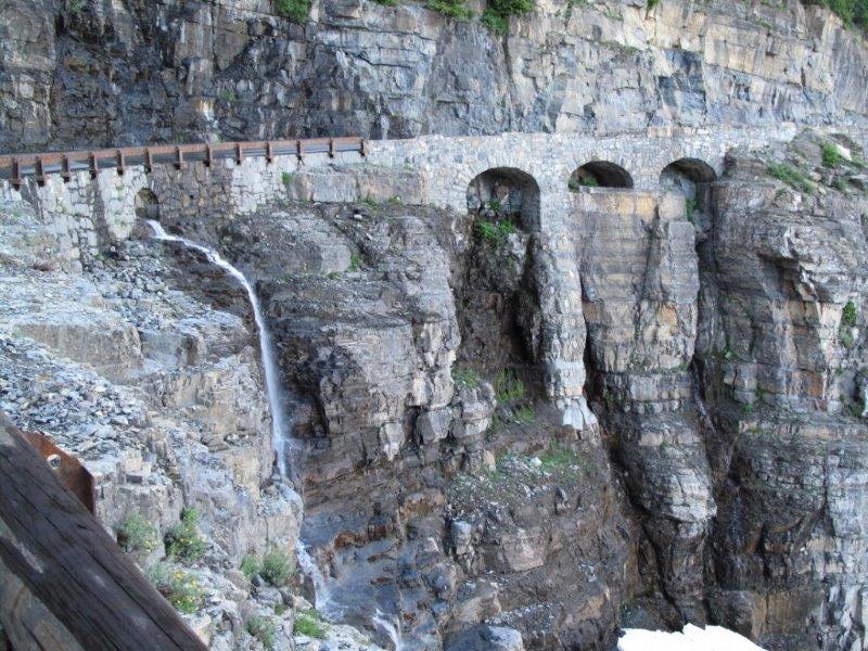
road until later in the week. This road was cut into the side of the
mountain in 1932 and extends 53 miles.
The section going up to the continental divide was an engineering breakthrough with a drop
off cliff off to the right the entire way up. A little nerve racking to drive up!
We finally made it to Logan Pass, one of the first two cars
in the parking lot! I grabbed my
jacket, back pack, and hiking poles and we were going to attempt to follow the
trail to Hidden Lake, the only problem is the fog was so thick that you could
barely see 10 feet in front of you and we are hiking on snow with no clue what
was any direction. There were yellow
trail markers in the snow which George was happy to replace any that had fallen
for hopes that we could find our way back if they were all standing. There were a couple times I think we all
thought about turning around, but we forged on and caught the group in front of
us who was equally freaked out by the lack of visibility. Strength in numbers I guess, because all 5
of us now headed into the abyss. Honestly, there was a pretty sketchy area that
was steep and not having been on this trail was a little concerned where we
would end up if we lost our footing.
 |
| Trying to find the trail in dense fog |
 |
| Found footpath |
 |
| Came upon this marsh above the snowfield |
Our first friend along the way, a little marmot we found at
the lookout for Hidden Lake. A few
minutes watching him and then the skies opened up leaving us with a
breathtaking view of the lake below.
None of the peaks in the pictures below were visible our entire way up
to the lookout. Also this is near one of
the high points of the park, apparently mountain goats all live up in the high
alpine terrain and we saw a small heard of white mountain goats up on a
ridge.
 |
| Marmot |
 |
| Magnificent view all of a sudden when the fog lifted |
 |
| Hidden Lake |
 |
| New look
and feel now that we could see where we were going on way down! |
|
 |
| Already a whole line of hikers on their way
up |
At Logan pass there is a nice facility that acts as a ranger
station and gift shop.
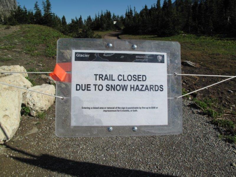
At Logan Pass is
also the trailhead for the famous Highline trail, but ranger said about 5 more
days until it’s safe.
More updates on
this trail in another day or so!

So adventures for Monday have only begun at Logan Pass, we have the whole rest of the day ahead of us. We drove back down the Going-to-the-Sun Road and with the clouds now lifted we had a whole new set of views to enjoy all the way back towards camp. At camp we refueled for our "more strenuous" afternoon hike.
 |
| This lil' guy was staking out our campsite when we stopped for lunch |
Before our afternoon hike Greg had stressed the importance
of visiting each of the turn of the century lodges in the park so we made a quick stop at Lake McDonald
Lodge.
This is an absolutely beautiful
building with giant pillars from big trees with logs of animal heads inside as
well as a great patio overlooking McDonald Lake.
The lodge was also one of the many stops for
the red bus tours through the park.
 |
| Rear Side of Lake McDonald Lodge |
 |
| Inside Lake McDonald Lodge |
 |
| Red Bus Tour anyone? |
Our next destination was Apgar Peak where there is an old
lookout tower.
In contrast to the snow and fog in the morning, the day really heated up so
it was perfect shorts weather.
This
trail is one way 3.3 miles and gains 1,850 feet.
We kept an eye on the weather and the week
guaranteed lots of sunshine, however Monday was the only day that had the
chance to get a little sketchy.
Finding
the trailhead was fun in the Subaru, dirt roads, old wooden bridges over rivers
and finally the end of the road which was also the beginning of the trail.
 |
| Old bridge on back road towards Apgar Peak Trailhead |
This was another beautiful trail which starts out fairly
flat first through some woods, then into an open meadow, and eventually it
appears that the last part of the trail is where we would gain most of the
elevation.
Greg was feeling good, so took off while George and I took
our time snapping a few photos on the way up and just enjoyed the views. We could see a long ways off and had some
great view but it was apparent that a storm was brewing and we were hoping it
would skirt us.
 |
| Halfway up to Apgar Lookout |
 |
| More great views on the way up to Apgar Lookout |
Greg summited first and was waiting on the lookout tower
when George and I made it to the top.
We had only time to snap a few more pictures from the summit and thought
it would be best if we got back down the mountain as soon as possible because
the storm that we had hoped would miss us was now right on top of us.
 |
| Storm moving in on us fast near summit of Apgar Lookout |
No sooner than we leave the lookout tower the wind starting
gusting, heavy rains, hail and lighting surrounded us.
There wasn’t a good place for cover so we
all decided to run like hell.
George took
off and Greg and I followed.
I was the
only one with hiking books while the two of them had running shoes so they were
a little more nimble.
I had a pretty
full water pack so it was excess weight so I opted to stop running for few
seconds and expunge all my water to lighten my load.
As the rain turned to hail it stung like
crazy as it pounded my head, face and body.
 |
| View from Apgar Lookout |
Soon we were off the steep part of the trail and back on the
flats, but it was still lighting, so again it didn’t feel safe so no break in
the dead sprint for the car. The trail
turns into a logging road on the flats with big tire ruts. No problem on the way up, but there was so
much rain so quickly that both ruts were filled with several inches of water on
the way through this time! Since my two
friends had running shoes they took off and I was left bringing up the rear, my
first time in the park in complete solitude and the thought of running up on a
bear crossed my mind once or twice.
About the time we all returned to the car the storm passed and we were
left wet and cold as the sun began to shine again.
No better time to return to McDonald lodge for a home cooked
buffalo burger in the bar overlooking the lake.
Tuesday, July 9th
St. Mary Falls & Virginia Falls - 6 Miles Round Trip
So our first 3 nights were spent inside the park at
Avalanche campground. Inside the park
did not offer the luxury of a showers, so by now we were ready to get cleaned
up so we packed our tents and planned to drive through the park from the West
Glacier area up Going-to-the-Sun Road once again (this road never gets old!) toward
St. Mary side of Glacier NP.
This time the route up was not foggy like yesterday morning,
but bright and sunny. The road gets
busy so we got an early start and were one of the first cars through the
construction zone. Bicycle traffic is
limited to non-peak hours so we saw a few cyclist pedaling up the route as
well. Will definitely have to go back and try that sometime! We took our time up the route exploring a
little more the scenery on the way up.
Glaciers, waterfalls, the “weaping” wall, snowfields, etc.
 |
| Roadside View |
 |
| Still tons of snow in July! Burnt trees starting to recover from recent fire |
 |
| Waterfall under Going-to-the-Sun Road |
 |
| Brian by waterfall under road |
 |
| Weeping Wall |
 |
| Amazing construction here for the road! |
 |
| More waterfalls |
 |
| Sample bride in side of mountain! |
 |
| Waterfall going under road |
 |
| Have to be silly sometimes! Not as scary as it looks! |
 |
| More snow along the road |
When we made it to the top of the Logan Pass (Continental
Divide) there was a crowd gathered and we were greeted by one of the mountain
goats we had seen from afar at Hidden Lake now this time up close and
personal.
 |
| Mountain Goat in Parking lot near Logan Pass |
 |
| Highline Trail still closed =( |
 |
| Highline trail closed sign |
.jpg) |
| Gregg, George and I at the Pass |
We continued over the top and down the east side for the
first time. Our first stop was at Sun
Rift Gorge, a beautiful slot of water that had carved a path through the
rocks.
.jpg) |
| Sun Rift Gorge |
 |
| River at Sun Rift Gorge |
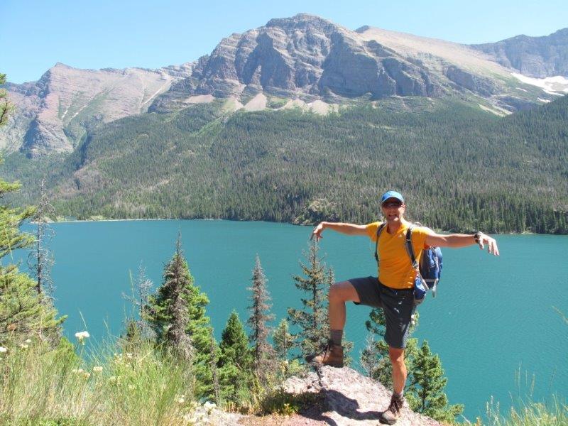
We continued on and enjoyed the views of St. Mary’s Lake on
the right and finally the visitor’s center at St. Mary’s entrance to the
park.
.jpg) |
| St Mary's Lake |
.jpg) |
| St Mary's Lake |
.jpg) |
| One of the most photographed parts of Glacier NP |
On to reserve our camp site at Johnsons and exit the park at
St. Mary side where there is a camp ground just outside the park boundary
called Johnson’s Camp Ground. (and has a
shower!)
http://www.johnsonsofstmary.com/services/campground/campground.htm
After a quick lunch at camp and then the afternoon plan was
to take one of boat tours at St. Mary Lake.
This was more than just a boat tour, the boat takes you to a remote
trail where you have the option to hike to 1, 2 or 3 different waterfalls. Of course we chose the option of all three. Along the boat tour we got to see Sexton
Glacier, Wild Goose Island, rugged cliffs, and ancient forests.


.jpg)
.jpg)

.jpg)
.jpg)
.jpg)


No comments:
Post a Comment