|
February 28, 2021
|
Chihuahua Valley Road to Angel Mary's Oasis
|
|
Mile 127.3-145.4
|
7:19 (moving) / 8:52 (total)
|
|
|
Max 5,658 feet (+3,178 / -3,826)
|


Pacific Crest Trail – Day 9
We had a great start on our first day of Section B with our new hiking companion Oobrianoo who joined us for the first hike of 2021 January 17th. We eagerly started planning our next outing continuing where we left off at mile 127.3 off of Chihuahua Valley Road. One of the many great things about finding someone also eager to tackle the PCT is having a 3rd person to help with planning and figuring out logistics. Now we have an extra person to bounce ideas off.
Every hike so far we had and easy road to access at the start and end of the hike until Day 9. While logistics is never exactly easy, planning start and end locations had been pretty easy. Like all other previous hikes after Day 1 we knew where we ended so we knew how to access the beginning of the hike which begin 6 miles down a slightly rugged dirt road. Our guide suggested 15.8 miles and hiking to Coyote Canyon Rd (Truck Trail?). I had no idea what to expect accessing this trail head so I began some legwork to find more information.
The start of the hike off of Chihuahua Valley Road was already in the middle of nowhere in a place I’ve never been but 16 miles deeper into the wilderness would take us into further unknow territory and near a town known as Anza. I don’t know much about Anza but I looked on the map for business that might be able to help. I found a website for a chamber of commerce but it seemed defunct. I next noticed some type of motorsports store and thought they might have just the right kind of characters that would know the back country, but the guy I called was not thrilled with my call and seemed like he had better things to do with his time than to talk to me. Next I found what appeared to be an auto dealership and the girl that answered the phone was more than happy to talk with me and suggested that the road we were looking for was washed out in a storm and not only would 4x4 not get you to the trailhead, but only a “tractor” would. In other words it sounds like it’s impassible. Yikes.
I was running out of choices to call in this little town then I found a number to Anza-Borrego Desert State Park Visitor Center where I talked to a ranger who was very helpful and provided a few pointers. Anza-Borrego Desert State Park http://www.parks.ca.gov/?page_id=638
I then saw that there was a real estate office in Anza and I figured I could connect with someone there and befriend them and they might just be willing to help me. I couldn’t have made a more appropriate call because I was put in touch with a lady named Allison who sounds like was the head of the former Anza Chamber of Commerce and also heads up the Anza Area Trail Town which supports and conducts research in the area of a sustainable trail system in the mountain communities of Southwest Riverside County. Anza Area Trail Town https://anzaareatrailtown.com/
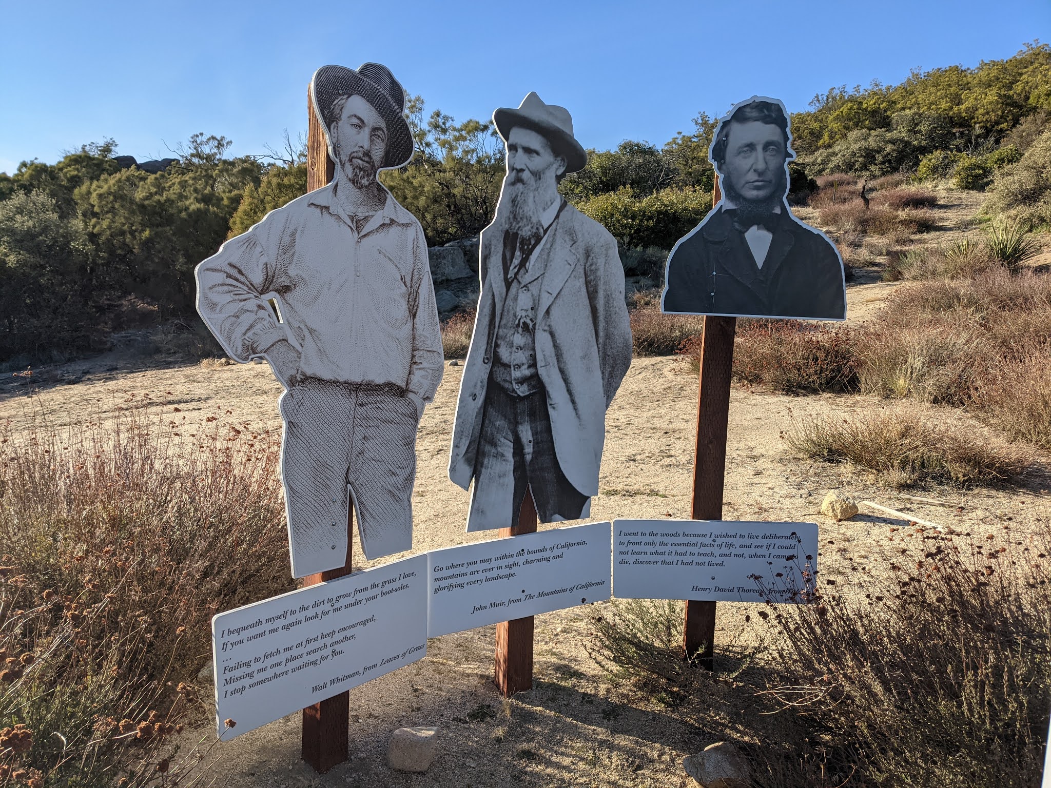
Allison is very familiar with the area and also pointed me to Angel Mary who owns property at 145.5 miles of PCT where she has an “oasis” where you can stop right off the trail. She has picnic tables, a library, 3 silhouettes of PCT pioneers, and even a big water tank to refill your packs. I got road conditions from Mary and she suggested as we had been previously advised that the truck trail might be a little sketchy and suggested we could park outside the gate at her property. It added 2 miles to our planned hike but that wasn’t a problem as we were just happy to know we found a place to leave a car and a destination to hike to. PCT 145 Trail Angel Mary: https://pct145trailangelmary.com/
I also found this site for Borrego Springs which isn’t right on the trail but looks like a great place to check out if you are traveling through the area. https://theabf.org/
So after all the planning and figuring out all the logistics the date was set for January 31 and as always we are always keeping any eye on the weather. Mid week it looked like there was going to be a severe winter storm which indeed hit. We confirmed with Angel Mary that most of the trail for our hike would be covered in snow plus the back country roads at each end of the hike might not be passable. We never had the need to skip ahead on the trail but began planning an alternative hike which was eventually decided to skip ahead to mile 444.2-454.5.
Hard to believe but an entire month later we were finally scheduling to pick up where we left off on the PCT. It seems like every two weeks is our cadence but it was Valentines Day on February 14th so we couldn’t make it back until February 28th. We coordinated with OoBrianoo and we had a long day in the works. 18 miles is already a full day of hiking but with trail logistics it was even going to be a longer day. First we had a 1 hour drive from Temecula to Angel Mary’s property to drop off the first car. It was another 1 hour and 15 minutes from Angel Mary’s property back to our trailhead off of Chihuahua Valley Road. We figured to get to the trailhead it would require leaving Temecula by 4:30 a.m. After a 9 hour hike we would have to make the 1:15 hour drive back to the start of the hike to retrieve the 2nd vehicle, then about an hour back to Temecula and another hour back home. Makes me tired just thinking about it.
So finally hike morning arrives and we are up before the crack of dawn, 4 a.m. to be exact. I pick up my phone to make certain our hiking friend is on the way as well as see another weather alert for the Anza area warning of high winds. Yikes, at 5,000 ft in the winter + high winds could spell signs for wind chill and already expecting temperatures in the 30’s I knew it was going to be cold, especially first thing in the morning. OoBrianoo show up right on time and has printed directions to our ending location at Angel Mary’s. She warned not to follow any online navigation because it always gets it wrong so we would look for the turn off onto her dirt road and follow the turns she recommended.
There are not a lot of places to stay in this area, we thought either Temecula or Hemet. We hadn’t been on Rt 371 before off of Rt 79 and it was dark so we really couldn’t see much until we saw some blinding lights up ahead and then came across Cahuila Casino Resort in the middle of nowhere which might have been the closest place to our trailhead if we had actually known about it. Terwilliger road was our last paved road as we turned on Coyote Canyon Rd and made our way to Angel Mary’s without getting lost. We parked safely in front of her place and was careful not to block her gate. We opened the doors of the car and the wind was howling and it was downright freezing. We grabbed all of our warm gear including gloves, hats, neck warmers, and jackets and jumped into OoBrianoo vehicle.
The sun had already come out so now we could see our surroundings. I’m always the one that is driving so I can never take in all the scenery along the road, but now as a passenger I got to soak it all in. About half way of our 1:15 drive I realized that I didn’t my sunglasses, afterall it was dark all morning on the first leg of my drive. Eye protection is always the first thing I grab when I get into the car, but there was no place to stop so I would have to go without for the day. We took the long winding pothole ridden 6 mile dirt road toward “Mike’s Place” and our trailhead. We passed Buddha and even came across 3 port-o-potties this time really in the middle of nowhere so made one last stop before our final parking location. I ran back to the car to stay warm.
A few miles further and we were back to the location we stopped a month ago. When we exited the car this time it was still windy and cold, but not near as brutal as when we dropped off the first car an little over an hour ago. I always have had my car at the beginning of the hike and now realized I also forgot my GPS watch in my car, strike two. I did have my backup handheld Garmin so fired it up and reset all the trip data and was able to capture the day’s hike with it. I especially like knowing how far we’ve traveled and it’s the easiest way for me to keep an eye on millage progress. We got a couple group photos and began the hike at 7:39. I think our original goal was 7 a.m. to begin but we way underestimated the drive time between trailheads.
We began the hike with all of our warm clothes on and while in the wind they kept us warm but when we were shielded from the wind and especially with the first couple miles ascent we slowing began to overheat and started to shed layers. We had been to this trailhead twice and knew we were a stones throw away from “Mike’s place” but we as it was either very early or very late we never had the opportunity to go check it out. We did look over our shoulder and from the point we climbed we could now see his place off in the distance behind us.
We push on and could clearly make out Combs Peak to our left. OoBrianoo had been here once before and actually peak bagged Combs Peak on his previous visit. We had a great view off to the right and could even make out the Salton Sea in the distance. Once we got to the final left turn when you could climb up to Combs Peak there was an amazing vista off to the right overlooking the whole valley. Now at the highpoint of the day we started a long slow decent for most of the rest of the day so we were able to make great time and didn’t need many rest breaks. I think we may have only stopped twice, the first time for snack break, and a little later a little longer for a lunch break.
We had done well and not gotten lost for several sections. We’ve learned if the trail all of a sudden feels really different it’s time to check the map or better yet the GPS. We had to go through a gate and then immediately came across a 2nd gate and also entered thru. Only a few short steps and we all figured we might have taken a wrong turn. We looked back and quickly figured out the trail took a left turn at the 2nd gate and we weren’t supposed to go thru so we were back on track in no time at all.
One of the great things about the PCT is every corner you turn you see something new. Today was no disappointment and we went through a big section of cactus including more barrel cactus than we’d seen anywhere in our first 130 miles. There were plenty of places for Kodak moments! We always try to guess if we will see any hikers, already half way done for the day, and a little cold Mai thought we may still run into 5 hikers, OoBrianoo said 0, and I said 1 horseback rider. Well to our surprise we ran across our first hiker heading southbound. We tried to make small talk by asking him if he had seen any turkeys. To our surprise he know way more about turkeys than any human I’ve ever met and we had a couple minute conversation about fowl along the hike. He was hiking solo because he couldn’t find anyone that wanted to hike out in the middle of nowhere with him. I think he mentioned he was hiking 25 miles so he was going to have an even longer day than us. We were feeling blessed that the three of us had found one another.
We passe over Tule Canyon Truck Trail and Coyote Canyon Road so were getting closer every step to our long awaited for Oasis. The last 4-5 miles were an easy climb, but at the end of a long day we all were starting to wear down and get a little tired. We were all looking forward what we would find at the Oasis. We were told “you can’t miss it” and just as we were approaching we ran into two more hikers coming our way. The sight of new folks on the trail always excites us an distracted us for a split second and we almost missed the turn off to the Oasis. I think I was expecting we had another half mile to go, but here we were. The picnic tables were inviting but it was starting to get late and cooling off so we just checked out the library, signed the guest log, saw the water cache, snapped the last few photos of the day and talked with the couple for 5-10 minutes.
It was their first day on the trail, all the way from NY and they were doing a couple week thru hike backpacking all the way to the Mexico border. The girl was younger and had already hiked the AT, but her companion was is far worse shape and seemed like this might have been his first time doing something like this. We gave them some tips on water (or the lack there of) and they filled there bladders before heading southbound. We looked at the map and realized we had to make a left turn on the dirt road to make it out to where we parked our car early in the morning.
We did see 1 horse at Angel Mary’s but for some reason I lost the bet on how many people we would see so I got voted to treat everyone one at Dairy Queen for some soft dipped ice cream cones. Before that tho I had a surprise in the car for Mai. I thought it would be cold all day and she loves her “hot” beverages, tea or even water. I had packed my JetBoil and quickly boiled a pot of hot water and made her favorite tea. It was all of a sudden really windy again at the end of the hike and with the sun setting the temperature was beginning to drop so I think the hot drink hit the spot for her.
We finally made it back to Chihuahua Valley Road after dark and took the road very slowly all the way back the 6 mile dirt road to our other vehicle. It was another hour back to Temecula and we had worked up an appetite and In-N-Out never sounded or tasted better. We were tired and in no rush to get home so we made one last stop. We got in too late the night before to take advantage of the hot tub at the hotel so I thought what could feel better for our weary bones then to jump the hot tub. It was heavenly!