Sunday, April 25, 2021
PCT Day 12: Cedar Springs Trail to Saddle Junction (Mile 162.6-179.4)
|
April 25, 2021
|
Cedar Springs Trail to Saddle Junction
|
|
Mile 162.6-179.4
|
7:38 (moving) / 11:32 (total)
|
|
|
Max 8,612 feet (+4,770 / -3,430) plus another +1,299 on Cedar Springs Trail to get to PCT
|
Pacific Crest Trail – Day 12
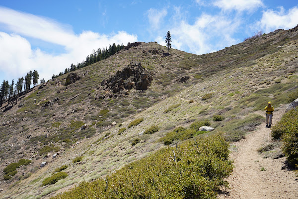
Day 12 continues where we left off in entering the San Jacinto Wilderness. Again this is really the section that I saw when driving through the area a few years back and thought to myself these look like beautiful mountains which had been calling me to explore ever since.
The PCT for Day 11 ended at mile marker 162.6, but then we had to hike Cedar Springs trail down 2.5 miles to where our 2nd car was parked. After a 10.7 mile hike it was a nice descent, however, we knew for Day 12 when we returned to pick up where we left off that 2.5 miles back straight up was going to be a torturous climb back to the PCT.
Similarly, one of the tricks of Day 12 would be figuring out where to exit the PCT. Our guide book suggested 16.8 miles on the PCT, which by the time we add 2.4 miles at the beginning then our exit would have the same scenario where we had to hike a side trail down to our car again. In this case it was another 2.5 miles which would tack on a total of 5 miles to the suggested 16.8 miles meant about a 21.7 mile day.
There were two shorter exits off the PCT down Spitler Peak Trail and another exit at Tahquitz Peak to South Ridge trail but both of those options looked like a they could be little longer side trails which would have to hiked up to start Day 13. So even though 21.7 miles seemed like a long day it still seemed like the best option.
There were a few more perils to deal with besides daylight. First was elevation. We would reach a new highest elevation on the trail of 8,612ft. While Mai and I had been each on our own hikes higher than this, together we’ve never been this high so I wasn’t sure how the long day and especially the elevation would effect her. Our hiking friend OoBrianoo would top out and this would be the highest elevation he had ever hiked. With elevation also comes cold/snow. It had been a light winter from a precipitation standpoint so most of the snow had already melted. Just to be sure we could avoid steep cliffs with snow/ice we purposely took a month off of the PCT for more springlike conditions.
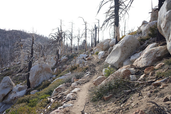
Our final obstacle for the day was the dreaded “rock slide”. PCTA website says, “There is a significant rock slide between Antsell Peak and South Peak around mile 172.5. The rockslide is dangerous to cross and impassable to some. The main rock on the trail is about 10 feet by 10 feet by 3 feet. We found a video on the rockslide on YouTube that gave us some idea of what to expect.
https://www.youtube.com/watch?v=76wX3RtflAw&t=667s
https://www.pcta.org/discover-the-trail/closures/southern-california/rock-slide-antsell-peak-south-peak/
I made a call to the Idyllwild Ranger district office to get an idea of conditions. She said a little snow, but won’t be a problem for the steep sections. Also she suggested the “rock slide” area has ropes and is not that big of a deal. The best news an upcoming section that had been closed for a couple years because of fire has reopened so we won’t have to skip this section so we should have smooth sailing thru mile 200 of the PCT.
Every hike we are always looking at the weather to see what to expect. Our hiking friend OoBrianoo and I joked because a month earlier I was gung-ho on hiking a day after a winter storm and he would suggest we head to a different section of the PCT where the weather would be a little less severe. Now this time I was keeping a close eye and already the end of April but the forecast I was seeing was showing Mount San Jacinto at a low of 12 and high of 31 without windchill so was suggesting we are going to freeze our asses off and maybe we should reschedule or do a different section at a lower elevation.
When I called the Ranger station a week earlier she said that Mt. San Jacinto usually is about 10 degrees colder than Idyllwild, but for the past few days the temperatures were basically the same. The thing is as soon as the weather changes it goes from really cold to really hot, so to delay the hike could force us into hiking in hotter temperatures. Since we were planning on a 21.7 mile day weather it’s cold or hot both could have their own challenges. We decided that we would bring warm clothes and go for it Sunday a.m.
Again logistics for a long hike like this required an early start. To get to Idyllwild by 5 am we thought we would take an hour out of our morning drive and stay again in Hemet. We stayed here once before two hikes ago and it was nice to make the morning commute a little easier. Our hike would be 4,770 feet of uphill on the PCT alone, plus another 1,300 ft of climbing to start the morning so we knew is was going to be a long day. Our wake up call was 3:45 and meeting time was 5 a.m. at the Ranger station in Idyllwild. OoBrianoo was already there after his long drive (and even less sleep) and ready to roll. He had already filled out a hiking permit and directed us to the box on the front porch for us to register. We had to provide starting and ending locations and information on our vehicle.
We followed each other to our end point to drop off his car at our trail exit at Humber Park. It was about 17 miles back to Cedar Springs trailhead and we would be ready to begin our hike at 6:30. The sun was rising on the other side of the mountain so the good news was that the 2.4 mile hike up to the PCT would be in the shade. We made good time and I don’t think we even paused for a break until we made it to the top in 1 hour and 16 minutes.
I zeroed out my Garmin watch for the next 16.8 miles along the PCT. No sooner than I had brought up in conversation about everyone’s guess of number of hikers we would see today on the trail we saw two hikers ahead which we never were able to catch. Every hiker we would see for the first time were 100% thru hikers. While hiking 22 miles in one day isn’t easy, most of the hikers we passed started at the Mexico boarder 12-13 days earlier and hadn’t taken a day off for a break tho it seemed that everyone’s destination was Idyllwild where there may be a day of rest for them. The first group that actually caught us was a group of three young gals that apparently went to school in Maine, one from Norway.
Once we got to the PCT there was short climb of about 250 feet up to 7,000 ft where it leveled off for two miles than descended for 2 miles back down 1,000 ft to 6,000 ft. We would max out at about 8,600 so for the rest of the day it was pretty much up hill from mile 4 (162.6). We saw a sign welcoming us to the San Jacinto Wilderness so we had officially reached the section of the trail we needed to register for our hiking permit.
We passed a lady, trail name Skeeter, and hiked with her for a little while. She said this is her 2nd time hiking the PCT as a thru hike. I think she was ahead of her group so she was happy for our company all the way to her end point of the day at Spilter Peak trail junction. Before we reached the junction tho we were ready for our first snack break. I had thought we were close to the top of a section but after lunch it continued to be tiresome up and up. We also passed the first group heading southbound, they were a group of three and seemed quite a bit older than any of us.
We came across a guy hiking by himself also a thru hiker. He needed a ride from Idyllwild trailhead to the town and was happy to join us and kept us company the rest of the day. He had a pretty heavy pack with all his gear but had very little problem matching our pace. We were quickly approaching the rock slide section at mile 172.5. Our first glimpse of reality of the trail when we passed a plaque that was put up recently for the hiker Trevor "Microsoft" Laher a young hiker that attempted this cliffside section in the snow a year earlier and lost his life. It was a reminder to take precautions and mediate as many risks as possible.
I had crafted a safety harness for us to use at the rockside to clip into the ropes that were attached and looked forward to giving it a try. Off in the near distance the rockslide was obvious as it completely blocked the trail. Our new friend was eager to show us how to cross and made it with no problems, however, after he was out of our site a few rocks were tossed down and fortunately he was OK. Next was Mai. She clipped in and was able to also cross with no problems. She was thankful for my hardness however I tightened the safety latch too tight and she couldn’t get it off. Even if she got it off it would be hard to get it back for the next person to use.
Next was my turn. I wrapped the rope around my hand twice for safety an moved slowly. Water was limited for the day and in the middle of the crossing I knocked my Poweraid bottle out of my side pocket of my pack and was able to grab it before it fell down the cliff. I didn’t want to take off my pack to secure the bottle so I tossed it over my shoulders back to OoBrianoo who grabbed it and secured it. Now with three of us across all that was left was our 4th who also had no problems. There was one smaller rockslide that was no problem and all the snow along the cliff was melted in all of the sketchy areas.
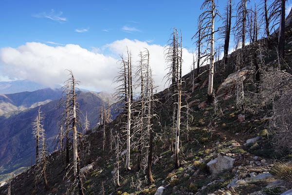
Next there were several downed trees which proved nearly every bit as hard to cross as the rock slide. We hadn’t been lost all day until mile 13-14 (about 176) where a tree was down on the trail right at a switchback which I crossed and then we lost the trail for a few minutes. This was one of the prettiest an most unexpected parts of the hike when it really felt like we were high in the mountains with beautiful pointed rocks all around. I would even go as far as saying mile 172 to about mile 177 was the most beautiful sections of the PCT since we began our hike at mile 0.
We started running into some snow fields and had to carefully cross. About mile 15 we really got lost following footprints in the snow and had to backtrack. Our party was split into 3 as we tried to find the trail and ended up back tracking to find the last place we knew we were on the trail and figured out our mistake again. This was about 11 hours into our day so we were already getting tired and the with the wind, snow, and the setting sun the temperatures started to fall.
Early in the day we talked about adding a side hike to Tahquiz Peak lookout but it was getting too late. It turned out navigating the snow fields plus crawling over many downed trees slowed us down considerably. With only two miles left to Saddle Junction we finally got a bit of a breather with a slight down hill all the way to Saddle Junction. I think we had worn out our new friend and he decided instead of hiking the 2.5 miles down to the car he would spend the night on the mountain and hike out in the morning. We said our goodbyes and were on our way.
We had to turn our headlamps on for the final 2.5 miles down to our car. Even tho downhill the GPS showed 2.8 miles to the car and took us an additional 1 hour and 22 minutes to go down Devils Slide Trail. The whole day would be about 22 miles and over 14 hours of hiking. I was pretty much spent when we got back to the parking lot. We didn’t find our car at first but just didn’t hike down far enough. When we found the car I was so happy to get off my feet. The pack of mini Oreos that Mai had packed were absolutely delicious.
I got a little rest on the 17 mile ride back to the first trailhead at Cedar Springs Trailhead. It did get cold after dark and we quickly jumped out of his car into our car for the long trip back to Los Angeles. We don’t stop at McDonalds very often but it was one of only a few options open after 9 p.m. and never tasted so good after a long day on the trail.
Subscribe to:
Posts (Atom)


