June 26, 2023 | Manning Park to PCT Northern Terminus |
7:23 (moving) / 9:55 (total) | |
Max 5,182 feet (+2,637 / -2,613) |


Links:
Pacific Crest Trail – Manning Park to PCT Northern Terminus
In February I booked a flight the end of June to Seattle for a week. There was no clear idea of how the days of the trip would be divided but a few of the must see's included North Cascades National Park and Rainier National Park along with exploring the Seattle area. With three years now of section hike the PCT there has been some conversations since we started at the S. Terminus how fun it would be to visit the N. Terminus.
No where on the PCT seems easy to get to and the N. Terminus is no different. I first discovered the link above "Getting There" and it looked as if there was too much red tape with the U.S. Canadian border that it didn't make sense to try as a section hike. Another thought was it would take a several day commitment or basically half of our planned vacation if were going to try to make it happen so it didn't seem like it was going to happen.
Believe it or not Mai was pushing to do it at all costs so I guess, "If there is a will, there is a way!" It seemed very unprobeable to reach as a day hike from the south so the only option was from the north. A resort in the British Columbia Mountains called Manning Park is located .7 miles from the trailhead so that is the place we would have to stay if we were going to make it happen. The round trip hike was allegedly 17.5 miles. It would take a day to hike plus a day to get there and a day to get back, but given all this Mai was still all in trying to make it happen.
We would make the N. Terminus the main part of our Pacific Northwest vacation and plan everything else around it. Of course, a 17.5 mile hike would require a little bit of training. I'm generally always active enough running and cycling that 17.5 miles wouldn't be too difficult but Mai has limited time to workout so it would be a little harder for her to prepare. Basically we just planned one long hike in the preceding months of April, May, and June and that would have to do.
As popular of a destination the N. Terminus is for a hike, there is actually very little information on the trail but we pieced together a plan based on a few links we found. The last obstacle was actually just getting to the trailhead and the biggest hurdle were passports and as (bad) luck would have it Mai's passport expired just days before our planned entry into Canada and we didn't realize this until it was too late for standard passport renewal options.
When we called the information line they suggested with the time for processing our best option would be to call 10 days before the trip and schedule an in person appointment for renewal. Only problem when she called all the dates in Los Angeles were filled and they wanted her to fly to Texas if she wanted to renew it before our trip. That didn't make any sense, however, she learned that there was an office in Seattle and they had an opening. The drawback is this would burn a whole day of our vacation but was the only way.
Meanwhile planning was in full swing and figuring out how to fit everything we wanted to see in the little time available. We would start in Seattle, head to North Cascades NP, on to Canada and pass thru Vancouver on the way to Manning Park, Hike the N. Terminus, head back to US and Mt. Rainier NP, with the last day back in Seattle.
Fastforward to June 23rd, good news Mai got her passport! After spending a marvelous day hiking in North Cascades NP we found a cute hotel in Concrete, WA which was close enough to the National Park that we could stay all day and not a long drive after our hike yet at the same time right on the way to Vancouver leaving us only about 100 mile drive in the morning.
I started to feel some good vibes about our day when we stopped to fill up the fuel tank. Also at the gas station was a farm stand selling fresh strawberries. A jolly fellow was working the road side stand and immediately noticed my PCT hat. Ends up he said when he was 19 he thru hiked the PCT. Now probably well into his 70's he still recalled the Southern California sections we were familiar. Similarly to 2023 it was a heavy snow year when he hiked and had memories of getting lost descending San Jacinto in the snow. Back on the road again we mixed the fresh strawberries with a white chocolate bar we picked up at a grocery store the night before and the two tastes couldn't go better together!
The border crossing went smoothly and within 2 hours we had arrived in Vancouver. Nothing seemed more touristy to visit than Granville Island which seemed like in the heart of Vancouver. We spent walked around the shops and had lunch then continued onward towards Manning Park. Google Maps switched over to Kilometers when re crossed the border so I had to do a little calculation in my head when we still had 218 KM to go to our destination which equates to another 135 miles. I had never driven thru the mountains of British Columbia but what we could see from the highway were quite beautiful. There is really only one artery going east/west out of Vancouver called Hwy 1 and on a Sunday had a lot of traffic heading back to the city, however, heading east we pretty much has open roads.
I was starting to wonder if I misjudged millage and gas as after we exited Hwy 1 onto Hwy 3 as there were no stops for fuel, but we made it to Manning Park no problem. Next gas stop 10 minutes further, but it seemed we would have enough fuel to get us back to the border where there would be refueling options.
I didn't know what to expect of Manning Park, for some reason I was thinking we had a little cabin but our room was in the main hotel. There was a small grocery store and dining option on site on the other side of the parking lot easily walking distance from the main lodge. It seemed as "hiking" was one of the main attractions at Manning Park as I noted a three ring binder at the check-in counter that had a whole bunch of hiking options. And wouldn't you know it, there was even a page for "Monument 78" which is basically another name for the N. Terminus hike we were to embark in the morning. They also had a large National Geographic PCT map on the wall that I admired. I hope to add one to a space on my wall when I return.
I asked the receptionist if she knew the route or more importantly where the trailhead was located. She seemed confident that it started at Lightning Lake, so first order of business was to set out before dark and see if we could locate the trailhead so we knew where we were going in the morning. A beautiful drive to the lake, however, lots of trailheads but not the ones we were looking for. The route isn't actually the PCT, it's trails that lead up to the PCT. Ends up the first part of the hike is called Windy Joe trail which has a fork and goes up to a lookout at 6,050ft.
We had no cell signal so our phones were almost worthless so we then drove further up Gibson Pass road until we seemed to be heading into the middle of nowhere. We next drove back out onto Hwy 3 and continued down to Beaver Pond Trailhead which might be another way to access Windy Joe Trail, but still not the trailhead we were looking for. One last trip back to the lodge to see if we could tap into their wi-fi and get some better directions. At last, it seemed as the trailhead was .7 miles up Gibson Pass road right past a river/bridge crossing. Bingo, we found the sign and our trailhead! Time to head back to the resort for some carbo loading. We didn't have anything prepared for lunch so the wait staff at the dining center was gracious and made a sandwich for the trail in the morning!
The end of June are long days, that is there is plenty of daylight. In Canada even more so. Sunset was more like 10 pm so there was no fear of being out after dark so we didn't have to get up at the crack of dawn for our round trip hike in the morning. We drove the .7 miles to the trailhead we scoped out the night before and there were already two cars there so we had hopes we might see someone before the day was over.
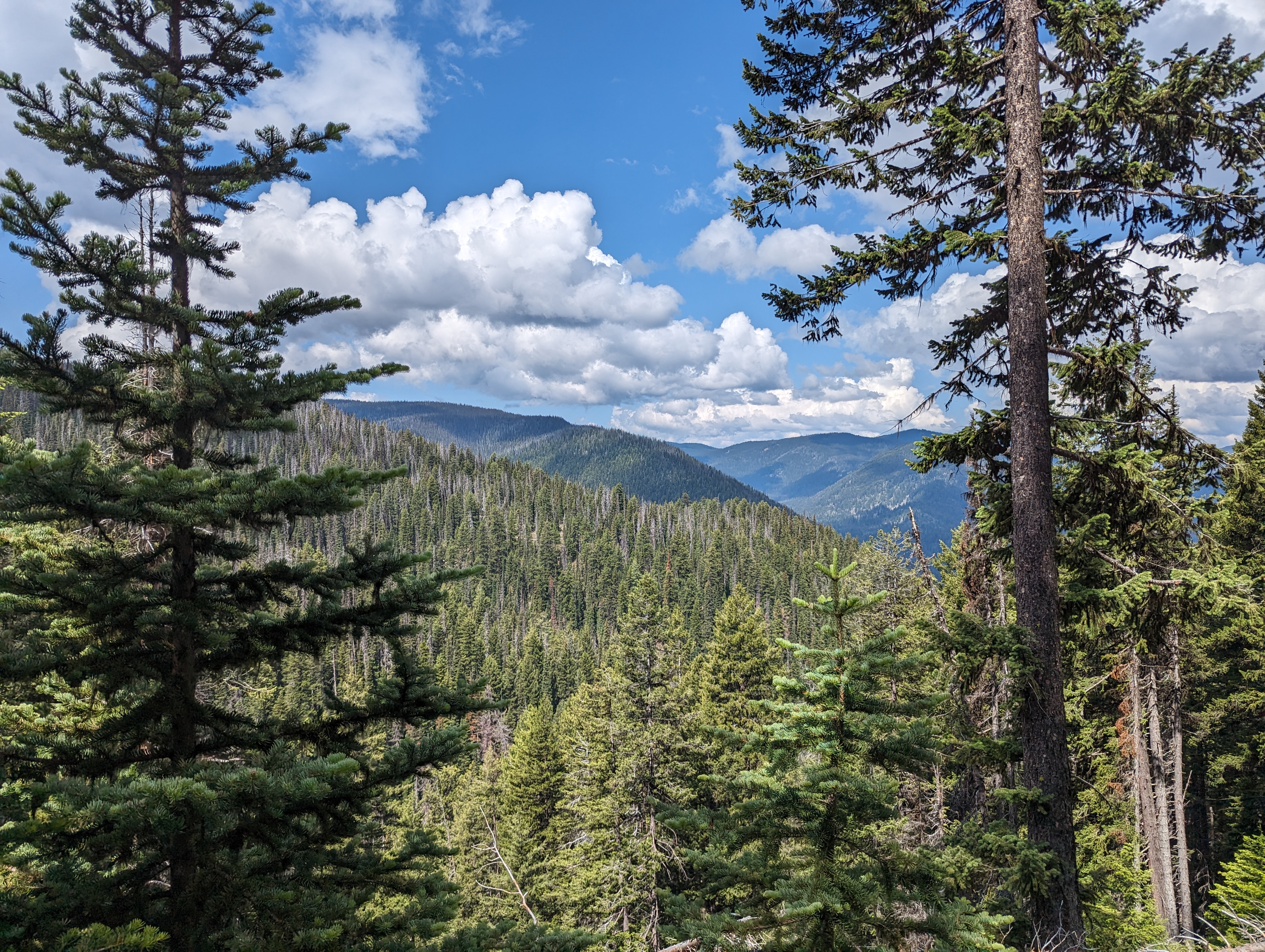
Unlike S. California everything is green and the rivers were flowing with tons of a water. We headed into the wilderness in good spirits as the sun was shining and it looked as it was going to be a great day for a hike. (more on this later) Without knowing the area I wasn't 100% sure of all the trail names and there seemed to be many different trails intersecting on our route.
It seemed as if there were multiple starting spots, the name of the trail we apparently settled on was called the Simikameen River trail. 2.1km (love the Canadian KM signs, had to do many calculations in my head to figure out how many miles) the trail intersected with Windy Joe Trail. Simikameen was more narrow, but after the intersection with Windy Joe it was wider like a back forest fire road. Windy Joe went straight up while Simikameen meandered along the river. Simikameen had red markers high on the trees, while after turning off there were no more markers. There weren't any millage markers but at every intersection there were great directional arrow signs pointing you in the direction we wanted to go.
Before we reached the intersection to Windy Joe lookout and the PCT/Mt. Frosty trail we ran into our first hikers. A couple had camped the night before at Monument 78. They had some heavy rains the day before, but for us the sun was still shining. Also the suggested the last 2 miles to the N. Terminus were heavily overgrown and had several fallen tree crossings. Ugh. Also there was a sketchy looking bridge crossing which they debated wading thru the river or crossing but suggested it was safe to cross even though a little crooked. While we were making pretty good time albeit we had been hiking mostly uphill all the way, it seemed as the last couple miles were going to be slow because of the terrain.
When we reached the Windy Joe lookout intersection it was almost 4 miles and were both ready for a snack/break. As we sat on a log two more hikers were coming down from Windy Joe lookout. I think they had also camped at the border the night before and decided for a little "extra credit" hiking up to the lookout on their way back. I asked, "How far" and not sure if I got an accurate answer, but I got the feeling it was only about 30-45 minutes up to the top maybe only 1 mile? (note: later we would discover this not accurate)
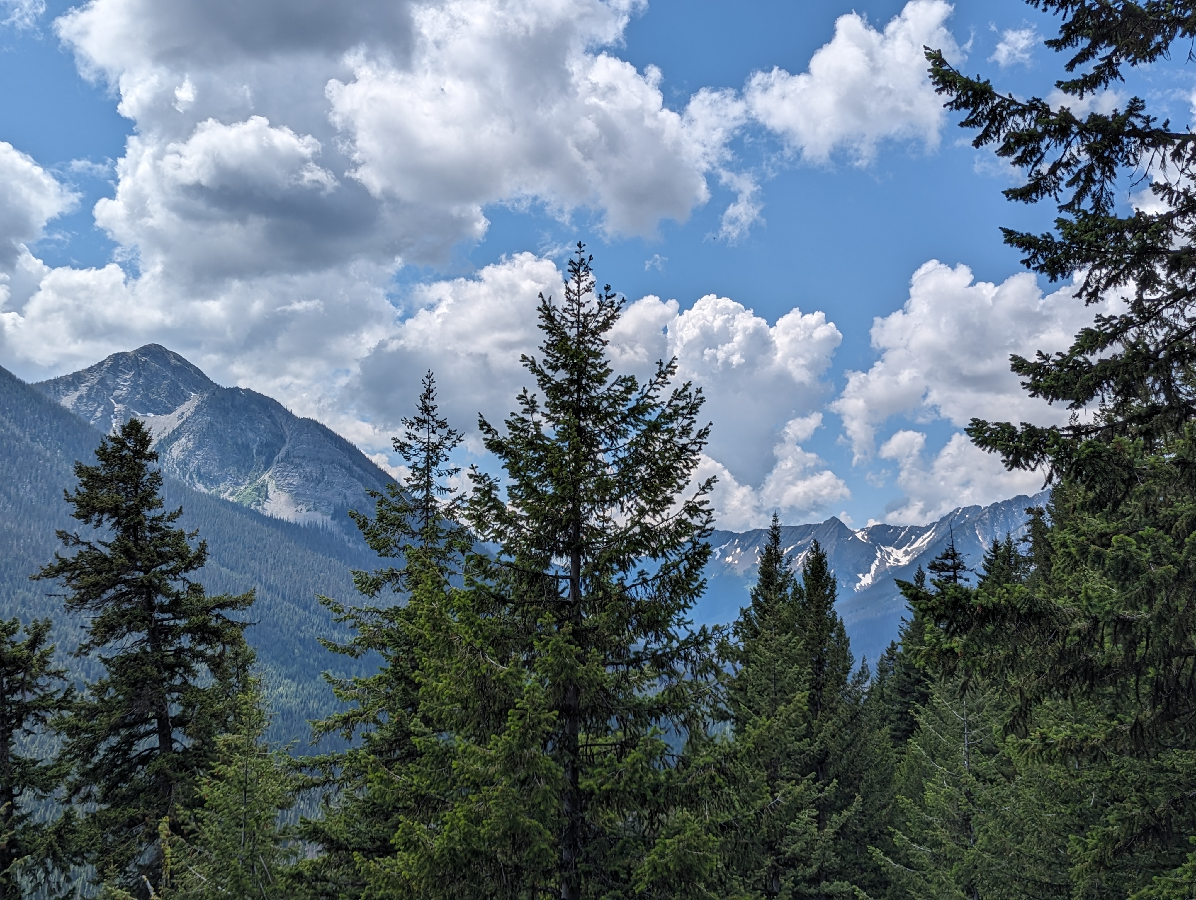
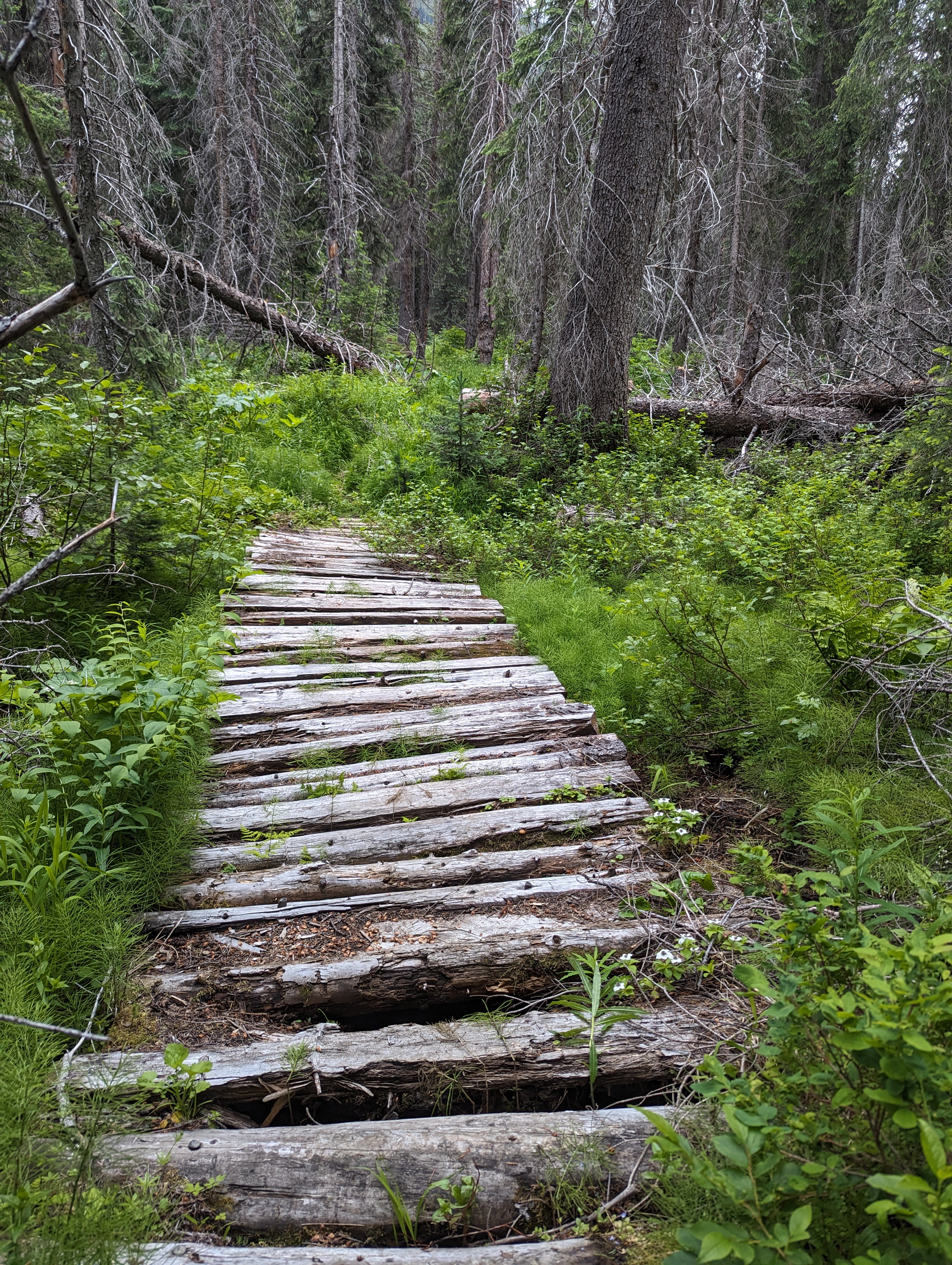
I'm not exactly sure where the PCT begins, but I have a feeling at the Windy Joe lookout intersection it's actually the start of the PCT. The trail narrows to single track and winds around the other side of the mountain. Soon we came upon a "PCT camp" which would probably be one of the last stops for thru hikers before they exit at Manning Park. The trail then got a little sketchy thru a steep section and almost required a bit of scrambling. The trail wraps around the mountain and turns to the right then starts a gradual descent. Once you make the bend to the right you have an occasional view of wonderful peaks that must be in the United states on the other side of the river. The trail is cut into a steep hillside and because of the overgrowth both Main and I stepped off the train and fell to the ground unexpectedly on several occasions.
We came across a single hiker on his way up. He didn't chat much but said there were a couple thru hikers at the Terminus. We were still on the right track and getting close. As the first hikers of the day suggested the trail gets a little hard to follow, we were grateful they hiked out and back and trampled down the vegetation a bit so it was a little easier for us to follow then it might have been for them. We had to crawl over and under a couple fallen trees but all in all the overgrown section wasn't too bad. I wore shorts and while the leaves constantly rubbed on my legs they were soft and didn't scratch me up.
We could hear the river getting closer so knew we were almost there. We were at last at the bridge crossing and I volunteered to go first. There was a cable to hold and the bridge was fairly narrow. Towards half way across the bridge I could no longer extend my arm long enough to hold onto the cable so had to let go and try to balance myself. I didn't know that Mai had also started hiking behind me and when I let go of the cable it snapped farther away from her and luckily she let go or it might have pulled her over the side of the bridge. After a brief scare we were both across.
Still in unknown territory there were no signs of the Terminus but we could hear talking in the distance. It might have been another 1/2 mile from the river, I'm not sure, but the anticipation was killin' me. At last we passed a sign welcoming us to Canada just before the terminus. There were 3 thru hikers, two girls that seemed like they were hiking together and a solo male hiker by himself. They had all started in the US and hiked here. Apparently, without a permit, they were not allowed to cross into Canada. So they had started in the US, hiked to this point and were turning around. The girls actually were North bound hikers that drove north to escape the high snow of the Sierras. The guy was beginning his South bound thru hike with the hopes to finish in November. No one is allowed to hike from Canada into the US, the United States only allows entry at valid border crossings. So while just starting he had to hike 20 miles here and turn around and hike 20 miles back. They guy had completed the Appalachian trail only a year earlier in 2022.
We talked, joked, and shared stories while enjoying our lunch. Also snapped a bunch of photos. We were disappointed to see someone unscrewed and removed the PCT marker at the top of the Terminus. There was a metal box and a registry behind the sign, so I wrote a little note to mark our visit. I had plenty of food and offered the solo hiker his first "miracle" and offered him a Snicker bar which he quickly devoured.
The spot is so surreal. While for us was only a 17 mile hike we know it stands for so much more as the "end" point for all the thru hikers. I've heard from multiple sources that the last 20 miles might be amongst the most beautiful of the entire trail. It's funny, as the crow flies we really were not that far from Diable Lake which we had just visited a two days earlier in N. Cascades National Park. It was a 4-5 hour drive away via the highway but it's probably only about 20-30 miles away. I think for sure I have to go back and hike that section of the PCT!
Full of joy of our accomplishment we knew we were only half way done for the day and had to start our hike back. Already we could see clouds starting to roll in and it seems as if there was a good chance we were going to get a chance to use our raincoats we had packed. The trail home was familiar now and not really a chance of getting lost. It was downhill all the way from Windy Joe turnoff and we thought we were going to have to slug all the way back up to the top. Fortunately, the slope was so gentle it didn't seem as if we were even climbing. About mile 10 into our day the rain started. It was actually pleasant and not cold so actually was fun as we reminisced about our Day 3 on the PCT when it rained and was crazy windy as we froze our asses off. Even an occasional thunder rumbled in the distance but never seemed too close for comfort. Eventually the rain faded a bit, but we would keep our jackets on the rest of the day.
In no time we were back to the PCT camp and could see there was a big group setting up camp for the night. We didn't stop and kept heading home until we got back to the Windy Joe lookout turnoff. I tried to use my salesman skills to pitch the idea of hiking to the lookout. Based on what I remembered from the guy's conversation I thought it was only 1/2 mile and 500 feet of climbing. Reluctantly, I think, Mai followed me but again the trail was steep as well as it was still sprinkling, getting colder as we got higher, and after a half of a mile it looked as if we were only half way there.
We went a total of 1.2 miles up Windy Joe before eventually deciding the weather wasn't good enough to keep going. From the fork in the road is about at 5,133 feet so nearly another 1,000 feet of climbing over 1.5 miles to the summit. It was farther than we thought and probably wouldn't have had much of a view with all the clouds now that surrounded us. She encouraged me to go for it but safety first I always believe that sticking together is always the best option.
The way back was a silent sludge all the way back the steep decline of Windy Joe trail back to the final left hand turn back on Simikameen where the trail flatten out all the way back to the car. We did it! Most importantly we still had time to make it back to the dining hall for dinner. We were a little wet and cold so were excited when the table we sat at the night before next to the fire opened up and they let us move and sit close to warm up.
Originally we were going to try to drive 1/2 back to Seattle after the hike, but we decided to spend a second night. We were pleased to learn that there was an indoor pool in spa in a separate building behind the lodge. Nothing quite compares to a hot tube after a long hike!


No comments:
Post a Comment